Please view our updated MetOcean Service Disclaimer
MetOcean smart buoys – remote insight into weather and sea state conditions
A selection of our lighthouses and buoys are equipped with meteorological and oceanographic (MetOcean) sensors and transmit their data to Irish Lights HQ.
We currently have a number of buoys and lighthouses collecting weather and sea state data. Measurements include average wind speed, wind gust speed, average wind direction, gust direction, wave height, wave period and water temperature. Values are posted on Twitter every 20 minutes.
This data is transmitted to our HQ via the Automatic Identification System (AIS) radio based communication network. The data for each location is published via an automated Twitter feed after some formatting. The MetOcean data can be stored, analysed, graphed via our MetOcean site.
For all queries or to provide feedback on the MetOcean service please email info@irishlights.ie
MetOcean buoys - Twitter
These lighthouses and buoys are equiped with meterological and oceanographic (MetOcean) sensors and transmit their data to Irish Lights headquarters via AIS. Here, the data is published to their Twitter feeds after some formatting. The Twitter timelines are listed under this Irish Lights Twitter list.
Fastnet Lighthouse
- Light Character:Fl W 5s
- Light Range: 27 nautical miles
- Radar Beacon: Morse 'G' on vessel's radar display
Fastnet Lighthouse Twitter: @FastnetLHouse
Kish Bank Lighthouse
- Light Character:Fl (2 ) W 20s
- Light Range: 21 nautical miles
- Radar Beacon: Morse 'T' on vessel's radar display
Kish Bank Lighthouse Twitter: @KishLHouse
Ballybunion
- Type 1 buoy, off the west coast of Kerry
- Nominal range of 6 nm
- Racon Morse of 'M'
Ballybunion Buoy Twitter: @BallybunionBuoy
Coningbeg
- Type 1 South Cardinal Marker (the largest buoy type in our inventory), off the south coast near Wexford
Coningbeg Buoy Twitter: @ConingbegBuoy
Dublin Bay
- Type 1 Safe Water Mark, situated in Dublin Bay between Howth and Dun Laoghaire
Dublin Bay Buoy Twitter: @DublinBayBuoy
For the latest tweets from the Dublin Bay Buoy, see the panel on the right.
Finnis
- First class East Cardinal marker, situated by the Finnis Rock to the east of Inisheer in the Aran Islands
Finnis Buoy Twitter: @FinnisBuoy
Foyle
- Type 2 Safe Water Mark, situated by the entrance to Lough Foyle
Foyle Buoy Twitter link: @FoyleBuoy
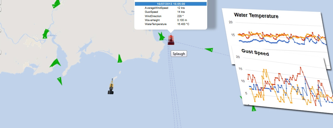
Splaugh
- Type 2 Port Lateral Marker (the second buoy type in our inventory), situated off the Wexford coast near Rosslare
Splaugh Buoy Twitter: @SplaughBuoy
For the latest tweets from the Splaugh Buoy, see the panel on the right.
South Hunter
- Type 2 South Cardinal Mark, situated off the coast of Larne
South Hunter Buoy Twitter: @SouthHunterBuoy
South Rock
- The South Rock Buoy is a Port hand laternal buoy marking the South Rock off the Co. Down coast
South Rock Buoy Twitter: @SouthRockBuoy
Data from these buoys is automatically interrogated, formatted and charted, providing a unique insight into weather conditions in the areas. These charts can be viewed on our MetOcean website.